It seems that California is under siege. In recent years, firePatel, Vimal. “Wildfires in California Killed Thousands of Giant Sequoias.” The New York Times, The New York Times, 20 Nov. 2021, https://www.nytimes.com/2021/11/20/us/california-fires-killed-sequoias.html. and erosionLogan, Erin B. “Winter Storm Triggers Mudslides, Clogs Roadways in Southern California.” Los Angeles Times, Los Angeles Times, 29 Jan. 2021, https://www.latimes.com/califo... wracked the state in increasingly dramatic fashion. These events represent not just an environmental crisis, but a crisis of politics. As these events unravel in causes both local and global determining the facts of the situation becomes increasingly difficult. Indeed, French philosopher Bruno Latour suggests that facts are so implicated with their social context and political affiliation as to have little utility. In the place of facts Latour suggests we pursue “matters of concern.”Latour, Bruno. “Why Has Critique Run out of Steam? from Matters of Fact to Matters of Concern.” Critical Inquiry, vol. 30, no. 2, 2004, pp. 225–248., https://doi.org/10.1086/421123... Instead of winnowing-down, Latour suggests a gathering-in, to collect all the complexities and all the scales of a situation and let them enter our discourse together. This sort of approach suggests a renewed ontology for a renewed public that would consider not just human actors, but nonhuman actors as well. To determine matters of concern is to engender new entities by way of expanded description.
In Los Angeles, we can begin with its mountains. The San Gabriel Mountains – which help hold in milder air off the Pacific and keep out the desert - are not just a backdrop. They are an active participant in the life of Los Angeles. As the Pacific plate collides with the North American plate, a network of faults spiders out, making the San Gabriel Mountains rise and the Los Angeles Basin tilt up. Earthquake activity aside, this sharp growth means that the mountains are some of the steepest in the world, and therefore the most susceptible to erosion. As tectonic shifting shoves them up, erosion crumbles them down. Erosion is accelerated by a cycle of drought, forest fire, and rain. Extended summer periods of dry, hot air set the stage for forest fires. Burned areas, in turn, set the stage for dramatic, rain induced erosion events made more dramatic by the steep inclines of the San Gabriels. Native chapparal vegetation – the only type to thrive in such a dry climate – make their own contribution to these events. Their resins – which help retain water during dry periods – repel water after burns. As less water enters the ground, it instead pours downslope, gathering speed and sediment as it rushes down the mountain.
Historically, such difficult conditions were treated as obstacles to be overcome. This tendency was evident as LA expanded in the 1930s. The city’s growth from 1900s onwards placed increasing stress on its land and water supply. Local agenciesThe Bureau of Water Works and Supply and the LA County Flood Control Districtallied with the Public Works Association and the Civilian Conservation Corps to attack these limits with the brute force of modernism, constructing both infrastructure and knowledge.
Two projects in the San Gabriel Mountains are indicative of this campaign. Begun in 1932, the San Gabriel Dam was erected to manage flooding downriver and to regulate groundwater for residential and agricultural purposes in the San Gabriel Valley and Los Angeles. Concurrently, a line was drawn around the Big Dalton and San Dimas drainage basins, encompassing thirty square miles of mountain terrain directly east of the San Gabriel Dam. Known as the San Dimas Experimental Forest (SDEF), this territory was devoted to building knowledge to understand and control the hydrology around Los Angeles. SDEF used labor to construct knowledge and the dam used knowledge to construct infrastructure.
At San Dimas, hundreds of laborers erected an array of experimental apparatus. The aim of these experiments was wholly instrumental: to find a way - by whatever means - to extract as much water as possible from the San Gabriel Mountains. In this search, determining the location and amount of water was foundational. Rainfall was calculated simply: hundreds of rain gauges - basically marked buckets - were installed at thirty-foot contour intervals over thousands of hectares covering the entire watersheds of the San Dimas and upper Big Dalton rivers. Set along crude trails, these gauges were maintained by dozens of workers living on-site in the forest’s primary settlement at Tanbark Flats. To measure the rainfall that flowed as surface water into streams, a series of fifteen small dams were erected and monitored. Groundwater was measured in a lysimeter, a long concrete vault roofed over with patches of vegetated soil that fed excess water to reservoirs within the vault. Collectively, these apparatus executed the modern project, converting sensory impressions to numeric data.
As the U.S. entered World War Two and exited the Great Depression, the profile of San Dimas changed. The funding and labor required to maintain its slowly evaporated. As few of its hydrologic experiments bore instrumentalA variety of non-native grass planted to sequester less water failed. Their root system was too weak, and the slopes on which they were planted washed away. Meanwhile, the lysimeter’s readings were deemed indiscreet, and ultimately useless. In the final accounting, the hydrology of the San Gabriel’s remain largely a mystery. Only 15 percent of rainfall is absorbed by plants or gathered in a stream. The other 85 percent disappears underground, making its way by unknown paths to unknown destinations.results the aim of the experiments changed. Water needs were off-sourced.In 1913, the Los Angeles Aqueduct was built, drawing water from the Owens River in the Eastern Sierra Mountains. In 1935, the Colorado River Aqueduct was built, drawing water from Colorado. In their stead concerns over erosion and fire became primary.
Today, the unstable ground measured at San Dimas is ever more fraught. Climate change has made droughts longer, fires more intense, and rainstorms (when they happen) larger. Expanding residential developments crawl up the mountains, moving further into areas at risk to fire and erosion. Over a million cubic yards of sediment accrues each year in the San Gabriel Dam Reservoir and is slurped back onto the mountains by dredging and trucking. Such rebellions betray any notion of the environment as mute and put its agency as an actor in our world front and center.
Latour considers this environmental irruption in his 2016 essay Down to Earth. Latour asks, “…how can we say where we are if the place ‘on’ which we are located begins to react to our actions, turns against us, encloses us, dominates us, demands something of us…”Latour, Bruno. Down to Earth: Politics in the New Climatic Regime. (Polity, 2018), 41.Latour foregrounds the way that the drive to expand collides with climate change to unsettle the ground we occupy. In Latour’s reckoning, place is the locus by which we form material attachments. To form material attachment is to encounter our situation not as a result of purely material or purely social causes, but as a complex milieu of actors both near and far. To arrive with at this place with clarity requires the work of description and builds the foundation for collective action: a public.“Existing as a people and being able to describe one’s dwelling place is one and the same thing...It is for want of territory that there seems to be no body politic.” Latour, Down to Earth, 97.
A critical encounter with SDEF models a way to form material attachments in Los Angeles. To understand San Dimas only in terms of the knowledge it produced is to dismiss the embodied work that took place on site, and the residue of that work in the extant infrastructure there. At San Dimas, the policies of both local and federal agencies adopted material form. San Dimas is not just an abstract machine of knowledge production, ignited by government policy, but nor is it just its material reality: chapparal canyons littered with a network of concrete channels and human architecture. Instead, SDEF is the network of entanglements that tie the drainage ditch around the bunk house to the data sheet outputs summarizing the rain gauges to the jurisdiction of the USDA Forest Service and the formation of climate policy in Southern California and beyond.
This project of description requires not just documentation, but representation. Documentation is sufficient for establishing matters of fact, but the creation of a public rests on matters of concern. In grappling with the climate crisis it is necessary that our encounters allow us to form material attachments. Representation permits space to define values aligned with material reality. Documentation rushes past meaning in a desire for accuracy. But when misinformation abounds, traditional facts are insufficient.“The soil allows us to attach ourselves; the world allows detachment.” Latour, Down to Earth, 93.The work of representation seeks attachment.
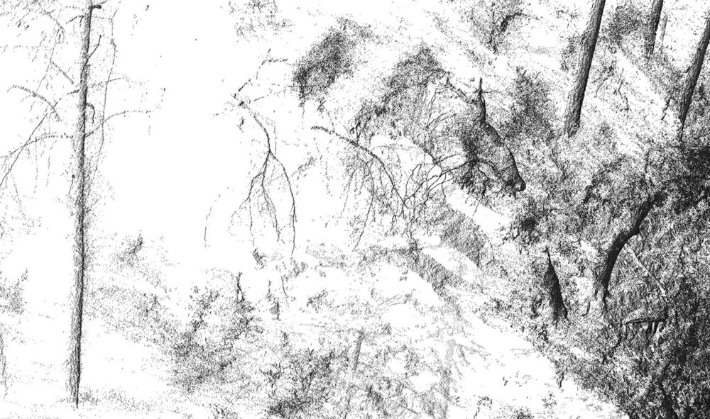
Lidar scanning offers a relevant medium for this project. Lidar sprays a laser beam over an area to construct a 3D surface map, known as a point cloud, to produce a digital duplicate of a physical original. Typically, these digital artifacts are exposed to regimes of extraction and analysis to arrive at a high-fidelity copy of the physical original – a matter of documentation and fact. However, if we consider the point cloud prior to such processing, it can emerge as a representational image – a matter of meaning and concern.