In 1960, the California Department of Public Works, Division of Highways officially informed the cities of El Sereno, Alhambra, South Pasadena, and Pasadena that studies were underway to determine a route to extend the Long Beach Freeway (710) through their cities to connect with the Foothill Freeway (210), a major east-west corridor of the Inland Empire. Despite widespread opposition and local speculation about where and if such an extension should be built, the official route – called the Meridian Alignment – was announced in 1964. Today, after nearly sixty years of resistance from homeowners, tenants, NGOs, property lawyers, local and state politicians, the un-built 710 extension has become known as one of the longest-running transportation land use disputes in American history.
A number of the original routes in Los Angeles County’s post-war Master Plan of Freeways and Expressways have never been built. The 710 extension will be the last section of that sprawling modernist vision not to be built. And yet, traces of this project remain legible in a vast archive of news articles, photographs, maps, drawings, and ephemera. There is also the significant architectural and spatial artifact of more than five hundred properties still under the management of the state transit authority that were purchased by eminent domain decades ago, slated for demolition to build the freeway that never came to pass. This collection of documents, spaces, and memories linger in what Norman Klein would call the subjunctive tense: the site of a freeway never built, but entered into the record of history nonetheless.
In 2018, Before Present organized an archival exhibition of materials related to the 710 and the extension dispute. This took place in Pasadena, in one of the houses originally slated for freeway demolition. The materials in the exhibition were sourced from previous tenants, neighbors, and local activists involved in the No 710 Committee, as well as the California Department of Transportation, regional libraries, along with new materials fabricated for the event. The following is a series of annotated excerpts from the exhibition archives, looking at the cultural and material history of the 710 and the freeway era from which it emerged.
Regional Planning Commission, Freeways for the Region (1943)
In the pamphlet Freeways for the Region, the County of Los Angeles Regional Planning Commission attempted to explain to the public why they should be enthusiastic supporters of what would soon become the region’s largest ever public works project: the freeway system. In 1943, high-speed limited-access roads were still only four years old and the very idea of a “freeway” had to be explained with illustrations and diagrams. The freeway was sold not only as a technology of convenience, but also for recreation, industry, and national defense. Land acquisition for the “Los Angeles River Freeway,” as it was called then, was said to be well underway, with 40% of the route secured.
Cloverleaf freeway interchange, design proposal for the Los Angeles River Freeway, Los Angeles Evening Herald, March 18, 1946.
The freeway promised both ease of use and new forms of aesthetic pleasure. But as the pre-war vision of the garden city parkway gave way to the post-war suburbanism of the freeway, the engineer’s vocabulary also turned from “scenic landscaping” to “functional plantings.” This 1946 illustration shows the shifting priorities of road engineers, as massive concrete interchanges become the dominant feature, accented by orderly fountains and palms. When construction on the Los Angeles River Freeway actually began in the 1950s, illegal landfills along the river had to be cleared and garbage was used to fill in the interchanges and create level ground. Today, one sees only dirt, shrubs, and a few trees collecting roadside debris.
County of Los Angeles Master Plan of Freeways, The Regional Planning Commission (1947)
This map shows the full extent of Los Angeles County’s ambitions for a freeway network across the entire region, circa 1947. Based largely on the “motorway” network proposed by the Southern California Automobile Club some ten years earlier, many familiar routes are visible. Others, such as the Santa Monica Parkway (through Beverly Hills) and the Ocean Beach Parkway (a widening of the Pacific Coast Highway) have never come to pass. The path of the “Los Angeles River Freeway” and “Concord Parkway” are highlighted, showing where the 710 would later begin to be built.
Renie Atlas, Commercial Edition, Los Angeles City and County (1959)
The signing into law of the Dwight D. Eisenhower National System of Interstate and Defense Highways Act of 1956 is often referred to as one of the most important national initiatives of the post-war period. At once a decisive move in cold war strategy and a confirmation of the suburban consumerist settlement, the “Interstate Highway Act” injected massive amounts of federal funding into Los Angeles County’s already ambitious master plan. This, and a constant growth in port shipping and trucking activities led to a renewed interest in the construction of a “Concord Parkway” to extend the Long Beach Freeway past its industrial terminus southeast of downtown. The immediate controversy of this extension was that it cut across the working class Latino neighborhood of East Los Angeles to reach the San Bernardino Freeway (10). As we can see in this 1959 Renie Atlas map (former property to the Division of Highways) an engineer has charted the future path with a blue dotted line, revealing a plan that extends not only to the 10, but also to points north, towards South Pasadena.
“Not so far off?” unattributed news clipping, 1959
Despite clear intentions to push the Long Beach Freeway through the northern suburbs, the state withheld the details of their plans for a number of years, managing expectations on both the practical and political level. Nonetheless, speculation was rampant for five years, in which cities along the route were left wondering whether they would be saved or destroyed by the state’s pavement.
Freeway System, Los Angeles & Vicinity, Automobile Club of Southern California (1972)
With constant freeway construction, road maps had to be updated frequently. The AAA’s pocket maps even showed when different sections of freeway were expected to open, so that a map printed in January would still be of some use in October. Here, we see sections of the Foothill Freeway (210) labeled with their scheduled opening times between November 1972 and April 1973. The 710 “gap” between Valley Boulevard in the south and Pasadena in the north is also clearly visible, as disputes over “freeway agreements” and the path of the extension are well underway.
Aerial Photographs of the Long Beach Freeway construction. Kelly-Holiday Mid-Century Aerial Collection, Los Angeles Public Library. (1961) [slideshow]
The 710 began construction in the city of Long Beach in 1949 and was almost entirely completed in the 1950s with the first 2.3-mile section opening in 1952. The freeway had been designed to run parallel to the Los Angeles River towards the Central Manufacturing District in Vernon and neighboring industrial centers in Maywood, Commerce, and South Gate. Although Los Angeles was not established as a port city, in the 20th century it became one, and the freeway was envisioned as an important link between these two hubs. In the early 1950s, construction of the freeway proceeded side-by-side with the concrete channelization of the Los Angeles River by the US Army Corps of Engineers. Division of Highways officials were pleased to report that significant construction costs were saved through close cooperation with the Army.
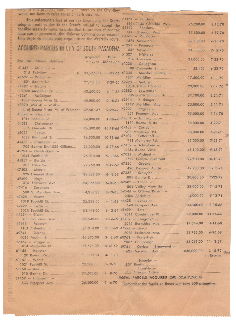
“Acquired Parcels in City of South Pasadena” unknown newspaper clipping (1972)
“Right of Way” has been one of the most locally controversial aspects of freeway construction, primarily involving the compulsory purchase and demolition of property. Even if the dangers of high-speed collisions, eight-lane gridlock, and toxic pollution were not yet fully realized at the beginning of the freeway era, the eminent domain notices and bulldozers certainly sent a clear message. Freeways became the purveyors of “creative destruction” and right-of-way agents the avant-garde of this movement. In this clipping from a local paper, a partial list of the properties bought up in South Pasadena by the state provides a rare inventory of historical prices. As the article notes, the freeway would have a considerable effect on the city’s tax base, as the final project would require the removal of up to six hundred properties across the region.
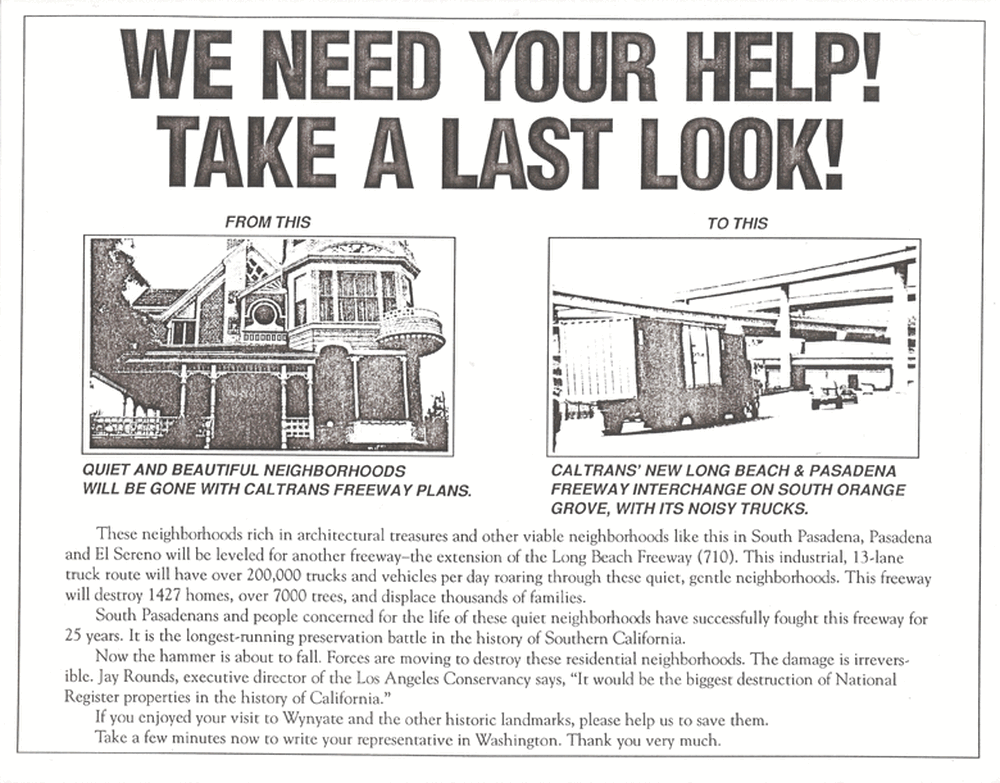
Trucks, Trucks, Trucks / We Need Your Help! Take a Last Look! (1987)
Local activism, especially in South Pasadena, was key to the resistance of the freeway extension. In the 1960s, the rollout of the federal interstate system was met with a wave of “freeway revolts” in many cities across the country. San Francisco successfully blocked a number of projects; in New York the work of Jane Jacobs was in part a response to the threat of urban expressways. In Los Angeles, the 710 freeway resistance went through a series of distinct phases, with various legal tactics addressing complaints over environmental impact, the freeway’s threat to historical preservation, as well as powerful arguments over the social and environmental justice implications of the project as it unevenly impacted various communities along the proposed route. In these flyers, we see that by 1987, a full arsenal of complaints were being mobilized.
By 1983, the Division of Highways had been reorganized into a new agency called the California Department of Transportation (Caltrans). A 1982 state law made it possible for Caltrans to proceed with freeway construction without the written agreement of affected cities, but the City of South Pasadena still sued to prevent construction from starting up again. In the meantime, Caltrans produced a propaganda film called Closing the Gap to garner public support for the freeway. In this clip, we hear about the two proposed freeway paths and the scores of historically significant and listed buildings that each would destroy. By 2003, so much time had elapsed between design and construction that the Federal Highway Administration rescinded its support for the freeway, calling for a new Environmental Impact Study that would take into account over a dozen recently designated historic structures, as well as a series of improvements to commuter and freight infrastructure that put the relevance of the 710 into question.
“Close the Gap” soft toy bulldozer (2016)
Although El Sereno (represented by the City of Los Angeles) and Pasadena initially signed freeway agreements in the 1960s, community resistance in El Sereno has always been strong and Pasadena rescinded its agreement in 2000. Alhambra, however, has been conspicuously pro-710 and has even mounted public events in recent years to support the completion of the freeway. Evidence suggests that this enthusiasm for the freeway has not been exactly grassroots, nonetheless, the existence of a counter-protest group has a certain sporting interest.
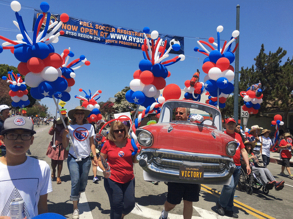
South Pasadena Fourth of July Parade, Freeway Fighters Victory (2017)
There is an annual Fourth of July parade down Mission Street in South Pasadena and for decades, members of the No 710 Committee have participated to raise awareness for their cause. In 2017 they celebrated their “victory parade,” marking the end of the 710 freeway conflict. In principle the extension of the 710, either by surface or by tunnel has been defeated. The Governor of California will soon sign into law a bill that will make it impossible to ever revive the project. As of 2019, Caltrans still maintains hundreds of properties throughout the Meridian Alignment and lawsuits have been filed over their mismanagement of the final sales process. Pasadena and the City of Los Angeles have yet to resolve how they will adapt the unused on-ramps and off-ramps, relics of the sixty-year dispute.
Satellite Composite of Pasadena, South Pasadena, El Sereno, and Alhambra with incomplete 710 freeway sections, between the 210 and the 10, Before Present (2018)
Tim Ivison is a writer and artist based in Los Angeles working on the history and political ecology of cities. He teaches Liberal Arts and History + Theory at SCI-Arc and also teaches courses in urban history and theory in the department of Humanities and Sciences at Art Center College of Design. Recent collaborations with the artist Julia Tcharfas include the exhibitions Operations Theater and 710 at Before Present, and Science of Rehearsal at the Swiss Institute, New York. Ivison holds a B.A. in Visual and Critical Studies and a B.F.A. from the School of the Art Institute of Chicago. He completed his Ph.D. at the London Consortium in 2017, where he studied under Mark Cousins. From 2014-2016, he was an Andrew W. Mellon Foundation Researcher at the Canadian Centre for Architecture.
Julia Tcharfas is an artist and curator based in Los Angeles. Her research draws on materials from modern scientific and technological folklore and often engages with design and performance of artificial natures. A profile about her practice is featured in the Swiss Institute’s ‘SI: Visions’ video series. Tcharfas is the founder of Before Present in Los Angeles and has recently exhibited work in Project 1049, Gstaad; Transformation Marathon, Serpentine Gallery, London; and Fluent Gallery, Santander.